CASE STUDY - Serving the Public More Efficiently
Commentary by Alex Bellak, GIS Administrator, City of Troy
Background
Troy is the twelfth largest city in Michigan, with 80,959 residents (2000 U.S. Census), and is the state’s second largest city based on taxable property value. Troy is located in southeast Michigan, less than twenty miles north of Detroit. Ten years ago, the City of Troy began using geographic information system (GIS) technology from ESRI to allow its citizens and employees to make informed decisions with timely, geographically accurate information. The city also implemented Crystal Reports from Business Objects as a cost-effective reporting platform for information dissemination.
Challenge
The City of Troy manages over 1,600 survey benchmarks, which are made available to the public to use as survey reference points. The engineering department receives numerous requests from contractors and the citizens of Troy to locate benchmarks on which to base new surveys. These benchmarks are the basis for accurately determining property boundaries and the location of new structures. The spatial nature of this task lends itself to a GIS application, but the official benchmark attribute information was maintained in an enterprise asset management system that did not include map features. To meet users’ needs, the desk clerk would locate the identification numbers of the appropriate benchmarks from the GIS map application, write them down, and then generate a Crystal Report from the asset management system. The requestor of the survey data would often also need an aerial photo showing the actual location of the benchmark. This required the desk clerk to use the GIS to generate a printed map.
The City of Troy wanted to utilize theInternet reporting capabilities of CrystalReports Server XI to request and receivereports that included both the appropriateaerial photo and the survey benchmarkdata. They also wanted to leverage thecapability of their ESRI Internet MapServer (ArcIMS) application to serve mapsat a scale appropriate to the benchmarkdata requested; for example, a map mightbe zoomed in to show only the benchmarkand the surrounding 300 feet.
Solution
APOS Systems, a partner of both Business Objects and ESRI, recently introduced the Solution Kit for ESRI, which provides a bidirectional bridge between the two companies’ latest offerings. The Solutions Kit enabled the City of Troy to leverage its investments in ESRI ArcIMS and ArcSDE GIS software as well as Crystal Reports Server XI Release 2. “It was very easy to implement and didn’t require extensive custom development. The end users were very accepting of the APOS Solutions Kit, as it made their job much easier,” said Alex Bellak, GIS Administrator, City of Troy.
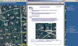
City of Troy, MI, Survey Benchmark Report

This publicly available survey benchmark report features text from BI, and aerial photo, streets, and benchmark location from GIS.
Benefits
The desk clerk now needs only one application to provide end users with all the information they require. The end user receives a consolidated report showing the survey data and benchmark location. As an added benefit, there is no chance of mismatching map and attribute data by interacting with two completely separate application environments.
Now all 400 City of Troy employees can utilize the reporting and mapping tools without the assistance of the IT department. This heightened visibility of the benefits derived from combining the power of GIS and business reporting has led to requests for more integrated applications. The IT department is currently working on map-enabling existing reports from the enterprise asset management system to provide more information to field crews, who rely on printed work orders and service requests. The field crews will then be able to see where they need to be on a map, instead of having to read through a document to find a location.
This article originally appeared in the issue of .